|
What Effects the Patterns Of
Precipitation?
Lesson Objectives:
Students will:
1.Identify possible weather
patterns from tracking and recording precipitation across the U.S. 2.Recognize differences in intensity of precipitation by using the key on their map 3.Evaluate how bodies of water and land formations impact precipitation Needed Materials:
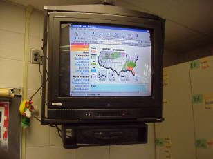
Five blank U.S. maps , one
to color each day for one week U.S. map including bodies of water, mountain ranges, desert regions, etc. Colored pencils Group work space for student collaboration and discussion Access to daily U.S. weather (newspapers, Internet access,etc.) Instructional Strategies: Where would we find daily information on precipitation? What might we be able to learn from watching the weather across the U.S.? What types of weather does each region on the U.S. typically have? Procedure:
1.Use the Internet to locate a
daily U.S. precipitation map. 2.Record the weather on a blank U.S. map daily for one week. 3.Encourage student discussion about their findings and the changes they see in the weather. 4.Analyze the weather within the regions of the U.S. over the week. What is the land/water in each region and what is it's weather ? 5.Draw some general conclusions about "What Effects The Patterns Of Precipitation ?" Assessments:
1.Share/ explain your data and
findings with another class. 2.Write a first person account as snow or rain and tell of your travels. |


|
HOME
|